Grading Improves Old Highway
8/3/2009
By Ivy Chang, Photos by Blake Neu, South Dakota Department of Transportation
In the rural areas of South Dakota, some of the roads and highways require little maintenance because fewer people travel on these roads. However, South Dakota wants its roads to be as updated as possible by using current materials and techniques to build pavements to specifications and accommodate its residents and out-of-state travelers.
When the Department of Transportation decided to regrade and realign state Highway 34, from Interstate 29 to one mile past Highway 13, officials looked at the hilly conditions and wanted to improve the sight lines for drivers as a safety measure.
“It’s primarily a regrading project, realigning an existing road, cutting down the highway horizontally and vertically, and filling spots to improve drivers’ sight distance,” said Craig Smith, area engineer in Sioux Falls. New curbs and gutters and storm sewer installation also are part of the project.
Remove pavements
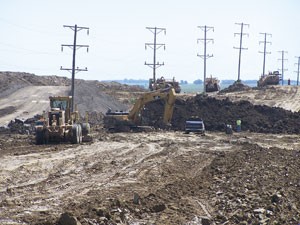
R & G Construction, Marshall, MN, near the South Dakota border, received the prime contract and began removing existing surfaces on almost nine miles of Highway 34. Smith said the contractors have to rebuild the entire roadway because of the existing small hills in this part of the highway.
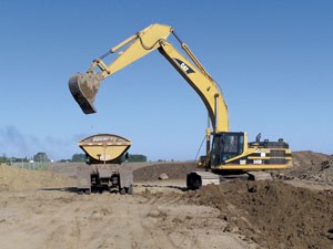
Gregg Mathiowetz, owner and project superintendent at R & G Construction, said his crew began rubblizing the concrete which will be reused and recycled, and the asphalt will be removed and recycled into the new base.
To meet pollution control permits, R & G placed erosion control measures, such as silt fences, around land owners’ properties to protect residents and livestock. “We will strip the inflow in the ditches to remove the existing surface, regrade the area, and put in new water pipes at certain locations. Once the area is regraded, we’ll place recycled asphalt on a gravel base to cut down on dust,” said Mathiowetz.
Smith said heavy grading will cut down some hills in the road by 10 to 15 feet. “We’re changing the elevation on a very old roadway. The pavement is in very rough condition. By completely regrading, we’ll end up with a smoother roadway. In some of the flatter portions of this project, we’re undercutting where we remove the existing surface, undercut three feet of materials, replace the three feet of materials, and then widen the shoulders.”
All equipment on site
The DOT acquired additional right-of-way to widen the highway. Smith said the project is creating new ditches, new in-slopes, and new back slopes to state standards as well as adding shoulders that didn’t exist before the regrading. “This is a rural project with one very small community where we didn’t acquire any right-of-way. In addition, we have to keep some roads open for residents to travel to and from their homes.”
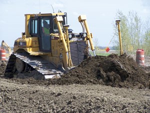
“We’re using our Caterpillar scrapers—627F, 627G, 637D and 637E—to cut the existing hills and take the excess material from the hills to the lower lying areas to build up the road, which provides better strength and better sight line,” explained Mathiowetz. “We have Mack trucks pulling side dumper trailers to haul the dirt around the project.” Currently, R & G has all of its equipment on the job site, including its Caterpillar 14H and 16G motor graders to help level the highway.
R & G is using a combination of staking and equipment with GPS during grading. “The GPS helps us to be more efficient. We know our cuts and fills and we hope the result provides a better ride surface when we’re done with the project,” said Mathiowetz. “The GPS in the grader tells the operator where to go and how much to cut and fill depending on where he is on the project. The program is on the equipment for the operator to use whenever he needs to use it. When the operator has to make a significant cut, he doesn’t need to see the length of the cut but uses the GPS to move the equipment on site to meet the specifications.”
GPS cuts time and work
Smith said some areas of the Highway 34 project require staking, and the bid states this option in the contract. “It’s common to see the extensive use of GPS on these projects. The state sets the elevation, and contractors come up with a method to check the elevation when they’re finished grading.”
For R & G, this grading project is a typical one with no new techniques. “Instead of using lasers and levels and looking at a stake to cut and fill, the equipment tells the operator what has to be done precisely. The other crew members can be doing other work, and, to a certain degree, this method cuts down a lot of time, eliminates a lot of mistakes so that we grade an area correctly the first time,” said Mathiowetz.
R & G has installed some GPS on its existing equipment and purchased other equipment with GPS. A computer specialist at R & G works with the DOT to reconfigure some of the programs before he installs them on the equipment’s GPS system. R & G has used GPS on its projects since 2002.
Grading is partially complete as crews now realign the road horizontally to decrease curves. Crews are moving about 850,000 cubic yards of dirt that’s unclassified, borrowed or removed from the project. The original grading was completed in 1930 with resurfacing work in 1988. R & G Construction will complete its grading and interim surfacing by November 6, 2009.
Phase II of this project, which is reconstructing another nine miles of Highway 34, will be done in 2010 with asphalt surface on the 18 miles to be placed in 2011.